Colorado Fire Risk
A reference example showing how to harmonize four geospatial datasets over
Colorado using src/geospatial_harmonizer.py.
Prompt
"Download these datasets, harmonize them to EPSG:4326 over Colorado, and generate a map:
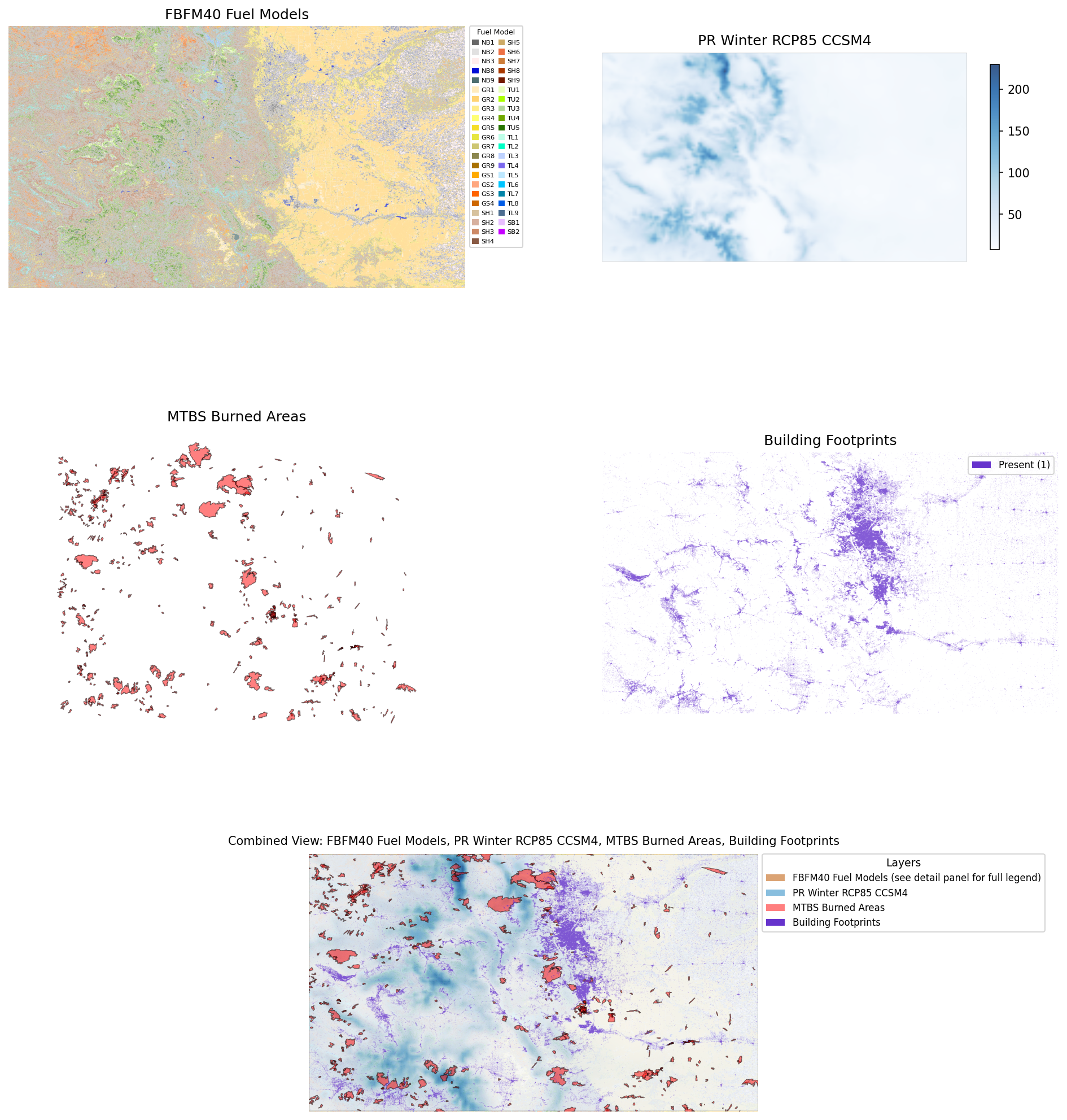
- FBFM40 fuel models (raster, categorical,
resampling_method="nearest"):https://www.landfire.gov/data-downloads/CONUS_LF2024/LF2024_FBFM40_CONUS.zipUse this CSV for both visualization colors (R, G, B columns) and legend labels:https://landfire.gov/sites/default/files/CSV/2024/LF2024_FBFM40.csv- MACAv2 winter precipitation via OPeNDAP (raster, continuous, variable
precipitation, months Dec–Mar):http://thredds.northwestknowledge.net:8080/thredds/dodsC/agg_macav2metdata_pr_CCSM4_r6i1p1_rcp85_2006_2099_CONUS_monthly.nc- MTBS burned area boundaries (vector, do not rasterize):
https://edcintl.cr.usgs.gov/downloads/sciweb1/shared/MTBS_Fire/data/composite_data/burned_area_extent_shapefile/mtbs_perimeter_data.zip- Microsoft building footprints (vector, rasterize to presence/absence):
https://minedbuildings.z5.web.core.windows.net/legacy/usbuildings-v2/Colorado.geojson.zip"
Datasets
| Layer | Type | URL |
|---|---|---|
| FBFM40 Fire Behavior Fuel Models | Raster (categorical) | https://www.landfire.gov/data-downloads/CONUS_LF2024/LF2024_FBFM40_CONUS.zip |
| MACAv2 Winter Precipitation | Raster (continuous, OPeNDAP) | http://thredds.northwestknowledge.net:8080/thredds/dodsC/agg_macav2metdata_pr_CCSM4_r6i1p1_rcp85_2006_2099_CONUS_monthly.nc |
| MTBS Burned Area Boundaries | Vector | https://edcintl.cr.usgs.gov/downloads/sciweb1/shared/MTBS_Fire/data/composite_data/burned_area_extent_shapefile/mtbs_perimeter_data.zip |
| Microsoft Building Footprints | Vector → rasterized | https://minedbuildings.z5.web.core.windows.net/legacy/usbuildings-v2/Colorado.geojson.zip |
Target grid: EPSG:4326 · Colorado extent (-109.05, 36.99, -102.04, 41.01) · ~270 m (0.00243°)
What Was Harmonized
- Categorical raster resampled with
nearestto avoid interpolating between fuel class codes - Continuous precipitation streamed via OPeNDAP — only Colorado pixels downloaded
- MTBS fire perimeters kept as vector, aligned to target CRS
- Building footprints rasterized to presence/absence (burn value = 1)
Result
Reproduce It
From the repo root:
python examples/colorado_fire_risk/colorado_harmonization.py
Outputs are saved to examples/colorado_fire_risk/output/. Large data files are
gitignored; only the visualization PNG and HTML map are tracked.
Source
Script: examples/colorado_fire_risk/colorado_harmonization.py